Showing posts with label cycling. Show all posts

Wednesday, November 02, 2011

How to do an East Coast Ride (for beginners and visitors to Taiwan)

The community over on Forumosa has helped a visiting cyclist from Japan put together a three-day ride on the East Coast, which is where Rank recommends that new riders in Taiwan do their first multi-day ride.

This is not just a route. The thread also has detailed advice on how to take trains and ship your bike back to Taipei as well as inside information on great, inexpensive places to stay.

This ride has it all. Swimming in mountain rivers, hot springs, the ocean, a few climbs (nothing major), lovely scenery of the Rift Valley, and lots of indigenous villages. Enjoy.

I think the thread does a good job of pointing our visitor in the right direction and helping him avoid making newbie errors such as riding on the west coast, Highway 9, and through Hualien City (he looks like he's going to ignore us on that one though).


Monday, March 02, 2009

Great Taipei Rides V: Bitan Loop

This is an easier variant of the Xindian Loop. Instead of turning right on Pingguang Rd. turn left and continue on around to the Xiaguishan Bridge (下龜山). Head back on 9 briefly until you reach Kangyalun Rd (康雅崙). This will take you through some pleasant little hills ( a few steep parts but not bad at all) and then around until you cross the Siyuan Bridge (思源) back to Xintan Rd (新潭).

You might want to avoid this route on Sunday afternoons since the traffic back from Wulai gets pretty bad on 9. Otherwise, this is a good second ride for a beginner.

Saturday, February 28, 2009

Great Taipei Rides IV: The Nangang Loop

Here is a Google map of a great ride you can do through the Fudekeng graveyard (Taipei Rides I) and to Nangang via Shiding. This road also eventually connects with the popular Fengguikou ride.

Update: Did this ride again last weekend (March 8). I now recommend taking Jiuzhuang Rd. (舊莊) down if you are going to Nangang. Here's a map. The loop took a little over 3 hours including a stop for breakfast at the Shiding junction. There is memorial to the Deer Hollow Incident at the junction of Dingnan Rd. (碇南) and Jiujhuang Rd.

This ride is about 45 km long and has a total of about 600 meters of climbing broken up the first climb up to Fudekeng (c. 160 meters) , a second climb to the border between Shiding and Xizhi (this is about 380 meters), and a third (160 meters) back to the top of Fudekeng.

Monday, December 15, 2008

Landslides and Discoveries

Rank originally planned to ride from Shuili 水里 to Chiayi this weekend using the route described in Great Taiwan Bike Rides IX: Yushan By the Back Roads. A major landslide though blocked our way out of Lugu's (鹿谷) Phoenix Valley (Fenghuanggu 鳳凰谷) above Xinyi (信義) and we were forced to double back toward Xitou (溪投).

As suggested in the linked above, we started from Shuili this time. Getting to Shuili was an adventure in itself. After a late start on the HSR, we arrived at Taichung Station around 8:00pm. A taxi driver suggested that he could take us to a bus station where we could get a bus to Shuili. He ended up taking us all the way into Taichung, where we eventually caught a All-da (總達客運) bus at 9:00pm at the delightfully funky terminal near Taichung train station. We had to wait for a bus large enough to fit our bikes in the compartment below as most buses to Shuili are small commuter buses. You can call the station on the day you will ride to check when the large bus will be going to Shuili. There is no definite schedule.

Unfortunately, the bus to Shuili goes everywhere in northern Nantou County before arriving in Shuili three hours (!) later. We could have rode from the HSR station to Shuili faster than that. I now realize that the best way to get to Shuili would be to take Taiwan Railways Jiji line (集集線) from the New Wuri Station (新烏日) adjacent to the Taichung HSR Station (Exit 3, Floor 2). The 3821 local, for example. stops in Wuri at 8:15pm and arrives in Shuili at 9:38pm. Bicycles must be bagged for both the HSR and local commuter trains.

After camping in a field a few kilometers downhill from Shuili on County Road 131, we cycled pleasantly up 131 t0 151, where we had lunch in Lugu. 151 is to be avoided wherever possible. It is a two-lane road full of traffic headed for the resort town of Xitou. If you are from northern Taiwan, it is a lot like Yangde Boulevard (陽德大道) heading up Yangmingshan. Fortunatel there are many side roads like 131. 131, incidentally, is a designated bike route that runs all the way from Puli to Lugu. This looks like it might well be a good intermediate ride through hilly but not too steep countryside. The junction with 151 is at about 350 meters. If you look closely at the map of the junction area, you should be able to see some alternative routes that will cut down your time on 131.

Just after Lugu Elementary School (鹿谷國小), we turned left on Renyi Road (仁義), also known as Nantou Route 56, and headed toward Phoenix Valley, which is in fact a beautiful gorge with excellent swimming holes at the bottom. The road eventually peters out at a place called Tiandi 田底 (not shown on Google Maps), and you turn right and go up the hill. Unfortunately, about .5km in there is a massive landslide that now blocks access to Xinyi and Highway 21 (see this this news report in Chinese). The slide is 500 meters across and 100 meters deep but may be passable for the very adventorous since the mountain has slid away leaving mostly bare rock. The main problem would be getting down from the edge of the road to the surface of the slide area about 3 meters below. Note that Google Maps is very inaccurate in this area--the Nantou road map at 711 is much better. Maximum altitude at top of the gorge is around 850 meters.

We doubled back to Renyi Rd. and took a left just after Fenghuang Elementary School (鳳凰國小) at 700 meters on Ertu Rd., which comes out on 151 in the pleasant town of Guangxing (廣興) at 500 meters. From here, we took Guangfu Rd. (光復) at the 711 down to the river and then hung a left after crossing the river onto Aixiang Rd (愛鄉). Guangfu, incidentally looks like a good alternative route to 151 from Jhushan (竹山). A few kilometers before Hanya (和雅) we camped in a bamboo grove off the road at about 750 meters.

The next morning we took Aixiang Rd. all the way to the last junnction with 151 and on to Xitou at about 1100 meters where we had breakfast. From there, Sishan Rd. (溪山) road took us up a series of moderately difficult switchbacks to a pass at 1800 meters. Here we turned right on Nantou 47 (投47線), which is marked on Google Maps as the Da'an Forestry Rd. (大鞍林道) Sanchalun Branch (三叉崙支線). The terraced teafields along this spectacular road are know as the Heavenly Ladder (天梯) and for good reason. Bring your camera. Despite the forestry road moniker, these roads are roughly paved with concrete. Road bikes not advised although my hybrid with 1.25" slicks did fine.

Originally we had planned to take Nantou 54 (投54線) down 36km to 149A (149甲) in Caoling (草嶺) and on to Fencihu, but a landslide before the junction forced us to make a difficult detour through the tea fields above the slide. With just a few hours of daylight left, we enjoyed the long downhill into Jhushan on 47. Note this news report from October of this year reporting another slide further down 54. 54 is marked as the main branch of the Da'an Forestry Rd. on Google Maps. Given the very steep terrain and the many slides, Rank highly recommends placing a few phone calls to local village chiefs in the area or doing other research to find out which roads are in fact open. The slides we saw will probably not be fixed until the summer.

Reaching Jhushan, we quickly located the Ubus Bus Station on Highway 3. Alas, posted prominently in the window was a sign stating that Ubus will now accept only bagged collapsible bicycles. We had send our bike bags home, but the station personnel told us that they were very strict about only collapsible bikes. This is another unfortunate consequence of the biking craze in Taiwan.

But repairing to a local internet cafe to study our options, Rank soon realized that a whole host of secondary train stations now will ship bicycles (託運). This service used to be restricted to main stations that shipped scooters. These services have now be decoupled. As a result, the tiny town of Linnei (林內) just across river on Highway 3 (see area map) was able to send our bikes to back to Taipei. We caught at 4:30 pm train and, after a change in Yuanlin, were back in Taipei by 8:30pm.

The many back roads, the dry, sunny winter weather, and improved bike transportation in this area mean that Rank will be back in this area soon to explore more routes soon.

Sunday, December 07, 2008

Yangmingshan Riding Notes

I have never been a big fan of biking in the Yangmingshan area. Sure, it's beautiful. But there is too much car traffic on weekends and so many cyclists speeding around on road bikes that it can be dangerous. Still, since a Shilin-based rider took me up Fengguizui last summer, I've been hooked on the Xiwan Rd. ( 汐萬) that connects Waishuangxi with Wanli.

The problem with just riding up to Fengguizui is that it is too short. But if you ride over to Wanli, you are stuck on a hot, unpleasant coastal highway with a long ride to Danshui or a shorter one to Keelung. Neither of these are very exciting.

Today we tried to ride from Daping (大坪) in Wanli over to Kuangshan (礦山) in Jinshan. The idea was to rejoin the Yangjin Highway (楊金) and then take the Balaka Access Road down to Danshui from Zhuzihu.

We succeeded but may not repeat this route for some time. While the first section off the Daping Access Rd. is a very rideable single track, it later became steep and the bikes had to be carried for about 30 minutes. More skilled offroad riders will be able to ride more of this road, especially if they went in the opposite direction from Kuangshan to Wanli. The problem with doing it in reverse though would be the steep climb up the unpaved and rocky Kuangshan Access Rd. The three-way fork in the trail is on a ridge. Somehow we came out not in the parking lot but rather above the patch of geothermal activity. This forced us to descend down a steep trail and then pick our way through the geothermal activity. This Chinese-language site give s full account with some pictures--scroll down to the post by mosaico.

We left Shiling station around 7:30AM and were in Danshui by 4pm. We rode down to Danshui from Zhuzihu on the Balaka Access Road. This is a beautiful descent from around 1000 meters and has stunnning views of the ocean and the mountains. It's definitely the nicest downhill in the Taipei area.

Wednesday, September 24, 2008

Great Taiwan Bike Rides XII: Taipei-Fulong-Yilan

This ride goes through the back country of Taipei County through Pinglin (坪林) and out to Fulong (福隆). A short second day doubles back to Shuangsi (雙溪) and then down to Dasi 大溪 on the wonderful Shuangtai access road. See Robert's posts on hiking in this area.

From Taipei, ride out to the Taipei Zoo. My preferred route is to ride up to Fudekeng from Liuzhangli. You can also take Wolong St. (臥龍街) out to Jungong Rd. (軍功路) and left on Muzha Rd. Section 5 (木柵路).

Either way, you will want a look at this map when you reach Wanfu Bridge (萬福橋). After crossing the bridge, turn left onto Xinguang Rd (新光) Section 2. There is a little blue arrow on the map that gives the correct direction. Cross under the freeway, staying on Xinguang Rd. until it loops back onto the much larger Wenshan Rd. (文山). Here is a map of this confusing area. Stay on Wenshan Rd. all the way until it crosses underneath Freeway No. 5 and joins Taipei County Route 106. The advantage of this route is that you quickly bypass the horrors of traffic-choked Shenkeng on the other side of the Jingmei River.

On 106, you will quickly come to a junction with a couple of convenience stores, food stands, and, in weekends, a crowd of motorcyclists and bicyclists. Most people will be turning left and heading east to Pingsi. You want to go south on 106B (106乙) toward Shiding (石碇). Here is a map of the junction area. At the junction in Shiding, keep going straight on 106B. Here 106B is locally the Fengtian Rd (豐田道路). Actually you can also go right at this junction and end up on the Beiyi Highway (Highway 9) about 10 km from Pinglin.

I still prefer 106B, despite the fact that this once beautifully isolated road ( early 1990s) has been widened beyond recognition and now winds below the freeway. On the map of the area, it appear that 106B disappears, but if you zoom in you will see that it just goes under the freeway. The climb on 106B goes up to 600 meters on a forgiving grade in this direction. The downhill section into Pinglin is almost completely untouched by the freeway building in the area and the really nice parts of this ride begin here.

Just before Pinglin, turn left and go under the freeway exiting on a small road known locally as Shengsheng Road (上昇). Stay on this road and it turns into the Pingshuang Rd. (坪雙). This dreamy little one-laner is devoid of traffic. Stay to the right at the big Y junction and watch for signs for Shuangsi (雙溪). Map.

After about 15km of riding these hills at around 400 meters, you will descend into the Shuangsi valley and join Highway 2C (2丙). Take this through the impoverished town of Shuangsi all the way out to the coast and enjoy a few well-deserved beers on the beach.

Day 2

Ride back to Shuangsi on Highway 2C. Just before Daping Road (大平) crosses the river, turn left onto the Shuangtai Access Road (雙泰產業道路). Here's a map of the turnoff. If you get to the high school, you have gone too far. There is a fairly difficult climb up to nearly 500 meters, followed by a fairly flat section through a beautiful, isolated valley and then a sharp descent down into the surfer town of Dasi. From Dasi, you have a boring, flat ride on the coast onto Highway 2. In Toucheng, stay to the right and get on Highway 9, which will take you straight into downtown Yilan where you can catch the train back to Taipei and ship your bike back. A stop off in Jiaosi for a soak in the hot springs might be in order to break the dull riding after Dasi. Hint: soon after getting on Highway 9, take a right on Deyang Rd. (德陽) in Jiaosi just after the train station (map). This give access to some backroads that make for nicer riding. Much of the Yilan plain is a pit.

Sunday, September 21, 2008

Great Taipei Bike Rides III: Tucheng-Sanxia loop

Here's a great ride that takes 4-5 hours from the Yongning MRT station in Tucheng. You should be reasonably fit and used to climbing if you follow my route

3:00 Arrive at Yongning Station. Ride down Zhongyang Rd. past Foxconn's worldwide headquarters toward the freeway. I have some other alternatives here.

3:10PM Arrive at freeway underpass. Turn left across traffic onto Longquan St. (龍泉街). Start a 5km climb up to abou 200 meters. Lovely shaded road.

3:40 Reach the top. Turn right at the KTVs If you turn left, you will drop back down into Tucheng right back to the MRT station. Downhill to Taipei County Rd. 110. There are some nice views here in the late afternoon. Turn right on 110, and ride for about 1km. Turn left again at the gas station. Here's a map of the area.

4:00 PM Cross the river and head south on Zhulun Rd. (竹崙). At first there are some pretty large stands of betel nut on the slopes on the other side of the valley, but it gets wild and beautiful quickly. I had intended to turn right onto Taipei County Rd. 112 (Also known as Sancengping Rd. 三層坪路) and the ride over to the 4-way junction just outside Chajiao. But I missed the turnoff and went all the way up Zhulun Rd, a ride of about 10km. Again lots of shade in the late afternoon, and easy access to a creek just big enough to have some nice swimming holes. Good views on the way up this single-lane beauty. The United Daily News has a nice writeup in Chinese of the route using 112.

5:30PM Arrive at the Xiongkeng Recreational Farm. c. 750 meters. They have signs with the distance going up the whole way. An incredible sunset view of the entire Taipei basin. Better than anything you will see on Yangmingshan. There is a concrete access road out the back that is closed to regular vehicle traffic and NOT on the maps. This road will take you across the ridge at around 800 meters and then drops very steeply down into Youmu Village (有木). You must have a light for this section. There are a few turnoffs and no signage, but just stay on the road.

6:15PM Arrive in Chajiao. There is a lareg hot spring resort here. Stay on the small road (Tianfu Rd 添福 on the east side of the Dabao River all the way down to Sanxia. Here is a map of the area. Turn left onto Baiji Rd. Take Zongzheng and then Jieshou roads back to Tucheng for 5 or 6km of gritty city riding. You will go under the freeway, passing Longquan Rd. to complete the loop.

7:00PM Back in at Yongning station.

You should allow another hour for coffee, views, and swimming.

Monday, July 14, 2008

Great Taiwan Bike Rides XI: Northen Cross Remix

Update: Here's a Google map. Also, the trail between Taipei County 113 and Taoyuan County Road 119 has been graded and covered with gravel. [2010-3-30]

The Northern Cross Highway is an excellent weekend ride for beginners. But once you've done it a few times, you may feel it is a bit too easy, or you may want to beat some of the traffic that can mar this ride especially during the summer holidays. Here's a variant on this classic ride that is more of a challenge, includes a few kilometers of manageable off road fun, and is almost completely free of any city riding except what you do to get to the MRT station.

Saturday

6:00 AM. Arrive at Wanhua MRT station.
7:00 AM Yongning MRT Station.
7:15 AM After downing some 711 coffee we're off. The city riding can be even reduced further by just heading straight up Chengtian Road 承天路 behind Yongning Station (it's the one with the arrows), but we decided to have some fun exploring the roads parallel to Highway 3 (Zhongyang Rd. 中央路三段 in Tucheng) and were amply rewarded. I had just been thinking the other day about how little of the 'old' Taipei of the 1970s and 1980s is left. The back streets of Tucheng though are a decrepit but living museum of Taiwan's industrialization--and, I hasten to add, very pleasant and green on a bright summer morning.

From the side of the MRT station, we took a tiny lane (not on the map) parallel to Yong'an St. (永安街). Turn onto left on Yongping (永平) and then right about halfway past the middle school. Left back onto Zhongyang and then left onto Danuan Rd. (大暖路) at the the Foxconn corporate headquarters. If you really zoom in, you can see that it is possible to turn right under the freeway and continue on Zhongyang Rd. Section 4 Lane 67 past Dingpu (頂埔) Elementary School and back onto Zhongyang Rd. Section 4 , where you should turn left again. Stay on Zhongyang Rd. until it goes under the freeway, where you will see the entrance to Longquan Rd (龍泉路). Turn left on to Longquan. This is the end of your city riding until Luodong!

c. 7:45AM. Longquan Road. While that is the end of the city riding, it is the beginning of a good deal of climbing. Longquan Rd. joins Chengtian Rd. at the ridgeline between Tucheng and Sanxia. Longquan is a beautiful road that provides an invigorating climb up to 300 meters followed by a satisfying downhill down to Taipei County Road 110 also known as Ankeng Rd. (安坑路). Road 110 connects Xindian and Sanxia incidentally, but cannot be recommended because of heavy traffic and congestion near Xindian. We turned right on 110 and road for about 1km until we reached the junction with Zixin/Ziwei Rd. (紫微).


8:30AM Ziwei Rd. Ziwei Rd. loops behind Sanxia past the very active Baiji Temple, a regional center of faith at the end of fairly easy but unshaded climb up to 200 meters. After the temple, Ziwei Rd. morphs into Baiji Rd (白雞路) for a cruise downhill to the turn off for Jiatian Rd. 嘉添路. This is a left turn over a bridge after a few hundred meters you will run into a 711 store. Jiatian turns left again and doubles back toward the mountains down a pleasant country lane.

There are a couple of roads with bridges that look similar here, so make sure you are turning on the right road. Here is a map of the junction area. Obviously, you can turn at Minyi Elementary School as well.

9:00AM. We stop for some breakfast at the junction and then head up Jiatian Rd. toward the hamlet of Chajiao. By this time, the weekend traffic from Taoyuan County had really picked up as Taiwanese flocked to the hills to cool off in the Dabao River (大豹溪), which is probably Taipei County's most beautiful patch of undamed water--crystal clear water gleaming green in the sun framed by gorges that look like they are from a painting. While I really enjoy riding up the left side of the river on the Chajiao Access Road (插角產業道路), the steady flow of traffic behind me was, as we used to say in California, starting to harsh my buzz. Next time I will probably take the Zhulun Access Road (竹崙產業道路) to Chajiao which bypasses the traffic by climbing steeply over a 500 meter hill. The turn off to Zhulun Rd. is right by the Ziwei turn off on 110. This map shows the Chajiao area. Chajiao is where the roads intersect by the river on the right of the map.

9:30 AM Chajiao. Elevation c. 200 meters. Roll down the hill and turn to cross the bridge onto Taipei County Road 113, also known as the 
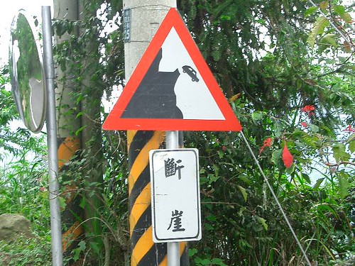
Dongyan Access Rd. (東眼產業道路). This is a tough climb up to 600 meters over about 7km. Taiwanese blogger Kevin has a detailed account of this road in Chinese and some pictures. The mid-morning sun was brutal, but we found a nice stream to cool off in.


As Kevin points out, you want to turn left at the junction at about the 6km mark. The right fork goes to Wuliao on 7B (7乙), which could make nice loop for a day ride. We turned left and continued to the end of Taipei County Road 113.

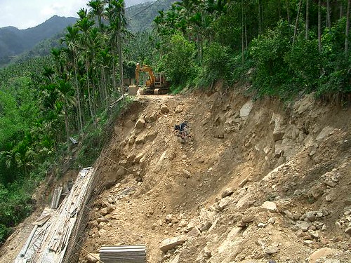
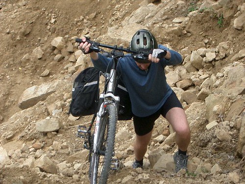
11:00AM The trail head. The trail connecting Taipei County 113 and Taoyuan County Road 119 (also known as the Fuxing Military Road 復興戰道) is the key to this route. The trail is about 2.5 km long and rises about 200 meters. Perhaps 40% is rideable going uphill. Real downhill riders could probably do 85% riding down. Bloggers Lao Song and Toujianiang have a full account with pictures (scroll down) in Chinese.

Even if you are not an offroad rider, this trail can still be recommended. There are only a few very short patches where you have to carry your bike--you can push you bike easily over the spots. We managed it with fully loaded bikes and my very poor choice of footwear (slippery leather sandals). I changed my tires to full on mountain bike tires (I've been riding on 1.25s for a while now) and P. was on hybrid slicks. Next time, I'll just leave my slicks on and walk the trail. As bike hikes go, this one one is a breeze. Much easier, for example, than the trail out Tonghouxi in Wulai, for example.

The trail is very clear. The only slightly confusing part is at the last big bend after a demolished shack, there appears to be another road/trail that goes off to the left. You want to go right.

12:45PM Emerge on Taoyuan County Road 119 (Also known on Google Maps as the Fuxing Military Road 復興戰道). 800 meters. Eight kilometer downhill.

1:15PM Junction with Northern Cross Highway (Highway 7). 250 meters. Lunch was river shrimp, cabbbage, salted pork, and fried noodles. NT$500.

2:30pm Northern Cross Star Coffee shop/rest stop. 400 meters. Slept on the benches in back and then chatted with the owner's son who will be studying environmental engineering at Tunghua University in the fall. Some late summer afternoon rains, which seems to be the pattern this year.

5:10PM Start riding again

6:30pm Arrive in Baling c. 500 meters. Stay at hotel next to the hot spring hotel. It is a few hundred NT cheaper than next door and has a very chatty and friendly owner. NT$1,300 for a double.

Sunday

5:30 AM We are off early to enjoy the cool of the morning. 20 km of one of Taiwan's most beautiful roads. Cross a pass at about 1200 meters a few km after Siling. There is supposed to be a hot spring below Siling in the gorge but still haven't hiked down to check it out. The climb in this section is about 10km and is the hardest stretch on this road. A nice downhill before Mingchi. A buffet breakfast for NT$150 a head is served here.

7:30 AM Mingchi After Mingchi, there is climb of about 1.5 km followed by about 4.5km of fairly flat riding as you emerge above the Lanyang plain. Next is a glorious 18 km downhill from 1200 meters to 350 meters.

10:00 AM Arrive at junction of Highway 7A and Highway 7. 350 meters We double back on 7A to check out the roads on the south side of the river. It's 3 or 4 km to the junction of the road up to Taipinghan. Here is a map of the area. While it appears at the level of detail that the roads do not connect, in fact they do. You want to cross the bridge here from Highway 7A and then turn left onto the Datong Access Road (大同產業道路). There's no traffic at all on this road which winds through one of those seemingly forgotten corners of Taiwan. This was is longer and there a couple of climbs up to 400 meters or so, but this road is a much better choice than juts heading back down Highway 7 on the other side. The Datong Access Road becomes 7C ( 7丙) and soon we are riding through the flatlands of Sanxing (三星) and entering Luodong around 2:00pm. Here are directions to the train station.

I shipped by bike back to Taipei by checking it into the baggage room but P took his bike apart and took it with him on the train. Since it was the summer holidays, the train was packed and we had to stand in the space between the cars balancing P's bike and moving our luggage out of people's way. Finally by 4:30pm we were back in Taipei and rushing off to celebrate a friend's birthday.

All in all, a great new way to do a classic ride by cutting out city riding, beating traffic, and getting a tougher workout by climbing a few more hills.

Friday, July 11, 2008

Great Taiwan Bike Rides X: Wushe-Lishan-Luodong

Here are some pictures of the road from Wushe to Lishan.

Friday 6:30PM Arrive at HSR station and disassemble bikes. Here we made a logistics mistake. We bought tickets online figuring the HSR might be sold out at this popular time. Unfortunately, picking up the tickets took about 20 minutes and we missed the 7:00PM train and our planned connection to Nantou City. I'd been meaning to ride the Lixing Access Road for some time, so the planned changed accordingly.

7:06 PM High Speed Rail Taipei.

8:06 Taichung HSR Station. Catch bus downstairs to Puli.

9:30PM Puli. Stayed at a small hotel just off Zhongzheng Rd. NT$1000 for three. Rank usually stays at the funky Sun Wang Hotel nearby which is about the same price for a double. These hotels are a block or so away from the bus stop, which is critical when you are lugging bikes and panniers around.

8:00AM Saturday After a quick breakfast, we caught the bus up to Wushe (霧社). The Nantou bus station in Puli is at the corner of Zhongzheng and Donghua (東華). This is a local bus with no storage, so we just brought the bikes on board. 

9:30AM. Arrive in Wushe, a picturesque Atayal town perched at 1200 meters above a large reservoir. We saw some other cyclists along the way, but there is too much traffic on this busy two-lane road for Rank's taste. Stock up on water on Wushe.

10:00 AM. We cycle out of Wushe, turning left onto Highway 14A (14甲) at the end of town. Here is a map of the area. Climb up about 200 meters over five km. or so and turn left off of 14A onto the Lixing Access Road 力行產業道路. This is a gorgeous one lane road with no traffic that winds through the mountains. Taiwan cycling at its best. The network of roads back here looks more confusing than it really is. You want to turn right onto the Fushou Road 福壽路 and head down into Lishan 梨山. The first 20km or so stay at about 1500 meters, but there is a brutal climb up to about 2200 meters just before Lishan through some high altitude farming country. There are a couple of villages along the way, but don't expect anything more than a bowl of instant noodles.

8:00PM Arrive in Lishan (2000 meters) tired, hungry, and cold. Stayed at the cheapest of this tourist trap overpriced hotels. NT$2500 for three. We did find a ramshackle Taiwanese-style mutton hotpot (羊肉盧) at the end of town that helped kill the chill.

6:00AM Sunday We hit the road early heading down out of town on Highway 7A (7甲) toward Yilan/Luodong. It was pear season, and although expensive, the snow pears 雪梨 were some of the best I've ever had. Someone also gave us some beautiful fragrant local apples, the best I've had in Taiwan by far. Descend to about 1600 meters.

9:00AM Wuling Farm entrance 2000 meters

11:00AM Cross the pass into Yilan at 2200 meters.

12:00PM Nanshan 1200 meters. The beef noodle place on the left as you come into town is fantastic--huge bowls of hearty soup and noodles that they make themselves here.

2:00PM Junction of 7A and forestry road (map) to Taipingshan (400 meters). If you have enough time (c 2.5 hours) you can turn right, cross the bridge, and take the Datong Access Road (大同產業道路 and 7C (7丙) back to Luodong. No traffic on this route. Otherwise stay on 7A and cross at the Taiya Bridge (泰雅大橋) into Sanxing (三星) and head back to Luodong on 7C. This is the faster route and is a good 10km shorter with fewer climbs. The roads up to the Taiya Bridge on this side have too much fast traffic on weekends including plenty of trucks. It's not horrible, but nothing like the idyllic ride on the other side of the river.

5:00PM Luodong. To find the train station (map), just stay on 7C , which is the local Zhongshan Rd. (中山路), crossing Highway 9 and Zhongzheng Rd. until you hit the railway tracks. Turn left and you are at the station. The baggage room is on the right if you are facing the station.

Sunday, May 11, 2008

Great Taiwan Bike Rides IX: Yushan By the Back Roads

The point of this ride is to ride south from Nantou County down to Chiayi but to spend as little time as possible on Highway 21, the New Cross Island Highway and Highway 18 (Alishan Highway). This ride is for fit experienced riders---you will ride up to 2,600 meters on the second day and there is a good bit of climbing the first day.

Friday

7:00PM Bag bikes and catch HSR down to Taichung.

8:00PM Catch Ubus (統聯) bus to Nantou City (南投) from Bay 16 downstairs. Bikes in luggage compartment below. This is the last bus, so don't miss the 7:00PM train.


9:00PM Arrive in Nantou. The Ubus stop is in front of a 7-11. Walk up the street past the Carrefour and the other bus stop. Hang a left and there is a cheap hotel NT$800.

Saturday:

8:30AM Catch bus to Jhushan 竹山.

10:00AM bikes assembled and breakfast eaten. Head east on Nantou County Road 151. This turned out to be a bit of a mistake since there is far too much traffic going up to Sitou (溪頭). Next time I will take the bus to Shuili and ride up 131 instead.

11:30 AM Lugu (鹿谷) take Nantou Route 56 east. The fun riding starts here.

1:00PM Baipuzai (白不仔). Take the unmarked road up behind the farmhouse and wind throughh the hills over to Sinyi 信義.

2:00PM Sinyi. Stay on the west side of the river and take Nantou Route 53 south to Fengguidou (風櫃斗). We were there in late December--the plum blossoms were just blooming. The road now turns into the Sinhe Access Road (信和產業道路) which winds through sleepy little aboriginal farming towns.

5:30 PM Jiumei (久美). Here we have to come down to Highway 21 for a few km until we reach Tongfu Village (同富) at the junction to the road up to the hot spring resort of Dongpu. We arrived late, so we stay at National Taiwan University's Forestry Experimental Station. It's a deal at NT$500.

Sunday--this was a long day
7:00 AM leave Tongfu by crossing a small bridge and riding up a country road on the west side of the river. No traffic at all.

8:00AM Rejoin Highway 21 40km of glorious switchbacks. One of Taiwan's most beautiful roads. Almost no traffic on a Sunday morning.

1:00PM Tatajia 2,600 meters. Lunch at Yushan National Park Visitor Center.

2:30 PM Alishan

4:00PM Shijhuo (石桌). Normally we would take 159A down to Chiayi, but it's late and that road is longer so we stay on the Alishan Highway. Traffic is heavy. You do not want to get stuck on this road in the dark on a weekday by the way. Many dangerous trucks. We were lucky and the Sunday traffic wasn't too bad. Still 159A would have been much nicer (this classic road is the starting point for many great rides out of Chiayi). If you take 159A, you can bag the bikes and catch the bus back into Chiayi at the temple complex called Bantianyan.


6:00PM Chukou. Since we were on the Alishan Highway, we caught the bus into town at Chukou and then transferred to a bus going out to the Chiayi THSR station.

9:00pm back in Taipei

Wednesday, March 26, 2008

Great Taiwan Rides VIII: Hsinchu to Taipei


Update: some good pictures of the ride up to Shangyulao by a Taiwanese cyclist.

Update: [2010-3-30]: Here's a Google map of the route. Rank will be riding this in late April.


This short overnight ride takes 1.5 days. Sorry no pictures. On the first day, you will climb nearly 2,000 meters, so this should be for fit, experienced riders. One of the best rides in northern Taiwan!

Sat. 7:00 AM: Taipei High Speed Rail Station (bikes disassembled and in bike bags)

7:45 AM Arrive at Hsinchu HSR Station

8:00 AM Load both bagged bikes into new hatchback-style taxi. These taxis are usually available at HSR stations.

8:45 AM Jhudong(竹東). Take Hsinchu County Route 122 east.

9:10 AM Arrive Wufeng Bridge (五峰大橋) in Shangpingli 上坪里. Taxi fare from HSR station was NT$700. Elevation c. 300 meters

10:00 AM bikes assembled

10:05 AM Cross Wufeng bridge and head east off on Hsinchu Route 63.

10:25 AM Reach Huayuan 花園. Turn left and cross bridge to reach Hsinchu Route 63-1 that winds up out of town. Route 63-1 is also known as the Tianhu Rd. (天湖道路) Note that if you turn right and stay on 63, you will reach the Luoshan Forestry Rd. which offers nice offroad riding. Buy water and snacks here as it is a good 10km uphill to the next reliably open store.

11:00 AM Xintianhu 新天湖. c. 900 meters.

12:00 PM Arrive at junction at Tiandana (天打那) c. 300 meters after a nice downhill through Meihua Village.

12:30 PM-1:30 PM lunch and nap

1:45 PM Head east and up on Hsinchu Route 60. This road is also known as the Jinping Houshan Access Rd. (錦屏後山產業道路). The first four or five km are a gentle climb up to Naluo 那羅. Make sure you get food and water here.

2:30 PM Arrive at Daoxia 道下. The last store is here (not always open), and the real climb begins here.

5:30 PM Arrive at Shangyulao 上于老 c. 1,450 meters. There is an excellent roadstop restaurant on the left across from the police station. Make sure you order the local mushrooms. There is an inexpensive, no-frills place to stay a few doors down on the left next to a coffee shop. NT$700. A more expensive Minsu is down the hill a few hundred meters.

Sunday 6:00 AM Leave Shangyulao heading toward Mashi (馬石) and Lidongshan (李崠山). This is the Mamei Rd. (馬美道路), one of northern Taiwan's best off road rides. While steeply downhill and a bit overgrown in places, even a novice off road rider can enjoy this. Lidongshan is a historical site where a Qing general (Li Dong) established an encampment and a group of Atayal died resisting the Japanese.

8:30 AM Arrive at Sangang (三光) elevation c. 650 meters. Turn onto Shalunzai Rd. 沙崙仔 Rd.

9:00 AM Breakfast in Sule (蘇樂) at the junction with the Northern Cross Island Highway (北橫) also numbered as Route 7. You can check out Great Taiwan Bike Rides VI for details of riding the Northern Cross east out to Luodong. We needed to be back in Taipei by late afternoon, so we headed west on the northern cross toward Sanxia (三峽).

10:00 AM coffee at the Ronghua Dam (榮華大霸).

12:00 PM lunch at the Swiss Chalet restaurant. Nice views, OK faux European food. More info in Chinese and pictures from this blogger.

2:30 PM arrive at Yongning MRT station.

3:00 PM Ximending MRT station

A suggestion--since it is now possible on weekends to take your bike on the MRT's Blue Line, you may prefer to ship your bike bags home from a 7-11 in Jhudong, so that you do not have to carry them during all the climbing on the first day.

Thursday, August 09, 2007

Bikes Permitted on MRT Weekend and Holiday Evenings

I haven't seen this mentioned anywhere in the English media, but you can now take your bicycle on the MRT on weekend and holiday evenings. This makes later afternoon riding in Xindian or Danshui much more practical. Remember, you can only take your bike on the Danshui-Xiandian or Beitou-Nanshijiao lines. Here's the official announcement.

Also, on returning from a ride on the Northern Cross Highway recently, I was able to take my disassembled bike in a bike bag on the MRT from the Yongning station in Tucheng back to Taipei on a Monday morning around 10am. The MRT regulations say that they can refuse passengers with oversize luggage, but they simply asked me to use the elevator. This is another option that makes all the great riding in the Sanxia area more accessible from Taipei.

Of course you can always ride out to Tucheng on the the bike path along the Dahan River.

Sunday, June 24, 2007

Great Taiwan Bike Rides VII: Route 197-Southern Cross Island Highway-Liugui

First a slide show...


Dennis Flood wrote up his ride a few years. His photos are much better.

Day 1

We flew into Taidong airport on the 6:30AM flight from Taipei. We arrived at Songshan Airport at 6am, which have us plenty of time to 'pack' the bikes. For those who haven't flown with their bikes in Taiwan, this means cutting up cardboard boxes (provided by the airline) and taping the resulting pieces onto your bike so that you won't get other people's luggage dirty. You do not have to take your bike apart, and there is no extra charge. Pretty cool.

A note of warning though--not every airport in Taiwan is big enough for a plane that can take your bike this way. Kaohsiung, Chiayi, Hualien, and Taitung are all fine. Pingtung's old airport was not. Not sure about the new one.

A second word of warning is that this great service may soon be over. I suspect that the increasing popularity of biking is starting to cause problems. We had a bit of argument with the baggage handling people at Far Eastern about this although we eventually prevailed. In general EVA (Lirong) is the most helpful while Far Eastern is more and more reluctant.

We arrived in Taitung hungry and exhausted since we had only gotten a few hours of sleep the night before. So instead of getting on the road immediately, we headed across the street to the restaurant/gift shop across from the terminal and had a hearty breakfast. This included a carimoya milkshake (釋茄牛奶). The wonders of papaya milkshakes have long faded for me, but this was a delicious new surprise even if a bit expensive at NT$70.

Well fed, we hit the road at about 9:30am--just as it was starting to get intensely hot. We wanted to avoid Highway 9 (台9線) and keep to the smaller county roads in the Rift Valley, so we made for Route. 197 which runs more or less parallel to Route 9 up the Rift Valley through the foothills of the coastal mountain range on the east side of the valley.

To get to 197 from the airport, turn left on Minhang Rd. 民航路 when you reach the T instersection on the road leading out of the airport. Stay on Minhang to the left and pass the Naruwan Hotel. You will cross a bridge and then reach the junction with Highway 9. Cross Highway 9 and you will now be on Highway 11B (台11乙). It's 4.1 km from here to the junction with 197 on your left.

We started climbing on 197 in the brutal morning heat. It's another 3 or 4km to Fuyuan at an elevation of about 300 meters. Make sure you bring water because the few shops and restaurants up here are not reliably open and there is little shade.

We rode the next hilly 10 km to the Luanshan Bridge (巒山大橋), stopping off at a small local temple near Liji 利吉 for a muggy, buggy afternoon nap. Somehow we missed the Liji hot springs although it may have been too hot even for me to try them out.

After crossing the bridge to Luye (鹿野), we had a fairly dismal lunch in a cantina by the 711. The people were friendly even if their food was bad. By the time we finished, ominous looking storm clouds had gathered and we heard from a traveling salesman type that it was already raining in Guanshan, our intended destination.

Rather than pushing on, we decided to head up the hill to Longtian and knock off early. Longtian, it turns out, was a sort of Japanese settler community and has the oldest nursery school in Taitung along with lots of beautiful old trees and a generous sprinkling of buildings from the colonial era. And of course there are hotsprings, although the main hot spring hotel in town was being renovated. On their recommendation, we headed to the end of town and aftera short downhill, turned left onto Taidong Co. Rd. 33 where we found the colossal Zixi Hotel ( 紫熹山莊) built entirely out of wood. A huge clean double was NT$2,200 and we settled into enjoy clean beds and hot showers. The food was inexpensive but tasteless jiancan (microwaved stuff out of packages).

Day 2: Longtian to Lidao

Greatly refreshed, we were on the road by 5:30am the next morning. We headed back across the bridge and continued north on 197. The road climbed up sharply to about 400m over four or five km. For next 14km the road is unpaved gravel. Unfortunately, a new layer of gravel had just been put down and was therefore quite deep and loose in some spots. There were a few spills as a result, but I would guess that in a month or so, enough traffic will have gone over the road to pack things down better and make it a good but unchallenging off road ride. This side of the valley is noticeably more tropical than the west side--reminded me a lot of Palawan in parts. There is absolutely nothing out here--you will need water and food.

At Bauhuashan Monastary (寶華山慈惠堂) there is a rest spot and a road that goes down to the Baohua Bridge. We stayed on 197 (paved at this point) and enjoyed a lovely downhill stretch into the rice fields on the valley floor. After another 3 or 4km of flat, we crossed the Diangguang Bridge (電光大橋) into Guanshan.

Guanshan seemed like a big place after the solitude on the other side of the river. We had a couple of filling biandangs from the Yuanchang Biandang Shop just outside the train station. The biandangs use the fabulous local rice to create a perfect meal for starving cyclists. Bellies full it was time for a nap. The airy Sun Moon Belvedere (關山日月亭) is at the end of Minquan Rd. (民權路) on the west side of town, and we unrolled our air mat to sleep for an hour or so in afternoon heat.

When we woke up, the sky was overcast, meaning that we could ride earlier than usual (on summer days I try not to ride between 10am and 3:30pm to avoid sunstroke). We headed back into town on Minquan and had some excellent lattes at a very old-fashioned coffee shop (Royal Bakery and Cafe?) on the main drag. Deng Lijun played on the ancient boom box and there was an excellent selection of pictorial magazines from the late 1980s to complement.

We left Guanshan by riding parallel to the Route 9 on Sanmin Rd (三民路) out to 大同 where we took a left. Datong curves around and turns into Taidong County Road 5 but there is a confusing junction near Hongshi (紅石). Ask at the betel nut stand if you are not sure which way is the right way to Haiduan (海端). Haiduan is just a few km down the road and you will come out on the Southern Cross Highway (Route 20) at around km 208.

From Haiduan, it is about 35 km to Lidao at an elevation of about 1000m. The grade is pleasantly gradual all the way to Wulu, about 10km from Lidao. There is a good, inexpensive restaurant across the street from the Tianlong Hotel. Am early dinner for two was NT$300 and was far more than we could eat. If you have time, check out the suspension bridge on the other side of the parking lot hotel--one of Taiwan's highest.

After Wulu there is a long climb through a beautiful rugged canyon that will remind you of Taroko. In the past, I've always done this section in the late morning heat. It was much, much easier and more pleasant in the cool early evening as the mountainsides came alive with the roar of cicadas, chirping birds, and howling monkeys.

We arrived in Lidao (elevation 1000m) just as it got dark and stayed at the Xianfeng Hostel (賢鳳民宿) for NT$1000. Basic but very clean. Xianfeng is run by a very pleasant young teetotaling Bunong couple who are tea farmers by day. I bought a half catty (斤) of tea for NT$750--it's excellent. There are a few shops where you can stock up on snacks for the next day and Big Sister Chen's (陳大姐) as you come into town is a good place for a hearty lunch or dinner.

Day 3: Lidao to Baolai

We were on the road before 6am the next morning and we needed all that rest for the glorious but exhausting ride that faced us. From Lidao to Yakou (亞口) it's 28km and 1,700 meters to climb. The road is achingly beautiful and cool because of the altitude. You need to be well prepared on this section with sufficient food and water and ready to get wet and cold. The fog usually sets in by around 9am obscuring the magnificent views but we had relatively good luck in that the fig kept rolling in and then rolling out producing spectacular Chinese landscape types of views. We finally reached the Yakou Hotel (at around km. 150) at noon and stopped for instant noodles and a nap. The last 10km is especially difficult because of the altitude. Take it slow and steady.

At around 1:30pm we were on the road again. Somewhat disappointingly, there were two coffee trucks at the pass (elevation 2700m) but no one selling coffee. Visibility inside the tunnel was very poor even with our lights because of the thick fog streaming in from the Kaohsiung side. Coming out of the tunnel you could barely see the side of the road for the first five or six km. That was disappointing because this is one of the most spectacular sections of road in Taiwan, but you should expect this after 9am. Still, the fog lifted a few km down the road near the Cypress Valley (檜股) and there were great views of the Laonong River making its way out of the mighty canyons at the foot of the Yushan range.

Contrary to Dennis's description, the downhill from Yakou lasts for a good 50km all the way down to Taoyuan. There is a gentle climb for about 250 meters a few kilometers outside of Meishan and another climb of about 500 meters in length (not elevation) into Taoyuan itself. The rest is all glorious downhills.

We really should have stayed in Meishan, but we had hot springs on our mind, and foolishly decided to push onto Baolai some 30km away. Meishan to Baolai (c. 20km) is 90% downhill, but the last 10km from Taoyuan to Baolai was up and down through the hills in the dark. Fortunately, there was almost no traffic and lots of fireflies. I actually kind of enjoyed it, but by this point we had been riding for nearly 14 hours (including rests) for well over 100km. This meant that I was afr too tired to shop around for place to stay in Baolai, which is a rip-off tourist trap like Jiaosi or Jhiben. We ended up staying at the New Baolai Holiday Village (
新寶來溫泉渡假村). NT$3,000 for a very mediocre double room and a scanty Chinese breakfast the next morning. All of this was forgotten though as we rooted the Yankees and Wang Chien-ming onto a glorious victory over the Mets.

We did make a new discovery on the main drag--No. 36 Aiyu and Coffee Specialty Shop (36號咖啡愛玉專賣店). Now I'm not generally a fan of Taiwanese desserts and ices (although iced Tofu and the Ice Monster's mango ices are important exceptions), but the jelly fig in ice with sour plums (酸梅愛玉冰) was one of the best summer ices I've ever had. I especially liked the tangy sour plums, which were probably the best I've ever had. Refreshing and not overly sweet. The coffee is good too.

From Baolai we rode down to Liugui (六龜) on Kaohsiung County Rd. 131 (note this is mislabeled as 113 on the Sun River maps) stopping at the waterfalls on the way. We would have taken 133 on the other side, but it is closed to repair a landslide, so we were forced onto Highway 24 (台24線). It's about 12km through rolling hills down from Baolai's elevation of 500m. to Liugui's 200m or so.

We took the bus from Liugui to the Kaohsiung high speed rail station in Zuoying the next morning. Note that the first bus (c.5:45am) does not go to the high speed rail station. The second bus at 6:45am does, and you can get there in time to catch the 8:30am train to Taipei. You will need to take the bikes apart and bag them to take them on THSR. We did this in Liugui the night before and put the bagged bikes in the bus's luggae compartment. I'm not sure you could get a full size bike in there without disassembling it.

A note on getting back. I strongly recommend putting your bike on the bus at Liugui or Meishan. The ride back to Tainan via Jiasian (甲仙) or Liugui/Meinung is hot, unpleasant, and hilly. The bus from Meishan goes through Zuoying, but I'm not sure it actually stops at the HSR station.


Sunday, May 27, 2007

Great Taiwan Bike Rides VI: The Northern Cross
Taipei-Sanxia-Baling-Yilan


We did this ride of medium difficulty at a leisurely pace by leaving Taipei on Friday evening. If you are an experienced rider in reasonable shape, you can do this ride in two days if you leave Taipei by 10am. Leave earlier in the summer to beat the heat.

We started off from Taipei at about 6pm on a gorgeous early May evening. We crossed the Zhongzheng Bridge 中正橋 over to the Taipei County side and rode on the bike paths out to Tucheng 土城 along the Xindian and Dahan 大漢 Rivers.

From Tucheng, there is a nasty 5 km or so along Highway 3. I'd recommend spending the night in Sanxia if you are on a budget. We headed up 7B (7乙 aka 北橫公路) over to Chajiao 插角 on the opposite side of the Dabao River 大豹溪, but the few B&Bs up there are quite expensive (c. NT$2,000/night) although nice. We stayed at Green Light about 2km up the road from the school and big hotel.

The next morning we were on the road by 7am. After getting back on Highway 7, we had breakfast in Sanmin 三民. Sanxia to Sanmin doesn't have too much traffic, but Sanmin to Fusing has a bit more than one would like. This section can be a real mess with traffic heading back to Taoyuan on Sunday afternoons. Sanmin to Fusing is a long steady climb with a 2km downhill just before Sanmin.

If you are coming straight from Taipei, one pleasant lunch option just before Fusing is the Swiss Village --nice views and (not bad) Taiwanese-style western food.

The traffic thins out on the long downhill to the Luofu Bridge 羅浮橋. You begin the real ride after Luofu. We stopped mid-morning for some overpriced coffee in the garden at Star of the Northern Cross (北橫之星 Beiheng zhi xing). A bit later we lunched on down home Atayal food at a pleasant semi-outdoor roadside cafe in Gaopo 高波. Good food, friendly people. We narrowly averted being drawn into what undoubtedly would have turned into an afternoon-long drinking session with an extended family visiting relatives in the village. This place is right on corner as you cross the river that plunges down the mountain and through the village.

After resting for a few hours in the afternoon heat, we slowly cycled our way up the vast river canyon that forms the headwaters of Fusing Reservoir. There is a coffee truck about 10km out of Baling at Ronghua 榮華 with excellent coffees. You may want to ask them not to add sugar. Great views of the dam below.

As usual, we stayed at the Beiheng Hot Spring Hotel (北橫溫泉山莊), which is about NT$1,500 for a double. We had originally planned to cycle up to the Galahe (嘎拉賀) hot springs about 10km up the road in Xinxing (新興) village. This is an undeveloped hot spring in a beautiful gorge, but it involves about a 500 meter climb up from Baling and a steep hike down into the gorge so we passed this time.


Galahe (嘎拉賀) hot springs


The next morning we cycled 20 glorious kilometers between Baling and Mingchi 明池. This is one of the prettiest sections of road you will see in Taiwan. The climb up to Siling 四陵 takes you up about 600 meters from Baling over 10 km or so. It's a bit of a slog but so beautiful you may not notice. There is another undeveloped hot spring in the river below Siling.

If you can make it to Mingchi by 9:30am, you can score a buffet breakfast in the cafe until 9:30am for NT$150 including brewed coffee. Make sure you bring enough food and water for the 20km between Baling and Mingchi. There is nothing but glorious nature on this section of the road.

There is a gentle climb of 2 or 3 km after Mingchi followed by a long downhill into Cilan 棲蘭 where you join the Yilan branch of the Central Cross Highway. It's about 25 km mostly downhill and flat after a few riverside rolling hills into Luodong 羅東. We put the bikes on the train at Luodong and caught the train back to the city.

Sunday, April 01, 2007

Great Taiwan Bike Rides V: Chiayi-Alishan-Meishan-Chiayi Loop

In case you haven't figured it out from my earlier routes, some of Taiwan's best cycling is in the Chiayi area.


A real Taiwanese glove


For a weekend trip, I recommend getting down to Chiayi on Friday night because you'll want to be off to a dawn start the next day--it can very hot down here at any time of year. Whether you're coming down by train, high speed rail, or plane, there are a host of reasonably priced hotels (c NT$800/double) in the small streets opposite the rain station.


Tea fields at 2,000 meters await you in Meishan

Day 1

The easiest way out of town is east on Minzu Rd, which eventually turns in to Daya Rd. before finally morphing into Chiayi Route 159A. Let all the tour buses and SUVs get their kicks on Highway 18 (the Alishan Highway) while you cycle in peace on 159A.


You'll cycle pass the Lantan Reservoir the Formosa Freeway, the Renyitan Reservoir, and Highway 3 through some hills. Note the junction with Highway 3--this is the way you will be coming back.

The oddly named 'Mainlander Noodles' shop.
All the noodle dishes listed are typically Taiwanese

After Highway 3, we knock about 8km in the nondescript countryside of Fanlu ('Aboriginal Road') Township. The fun begins just after the impoverished village of Kezhuang where you climb a few km up to the temple complex at Bantianyan. There is a nice outside cafe on the right just before the temples and some shops where you can stock up on food and water.


Be careful or this might happen to you on 159A

The riding gets really good here. 159A is a wild one lane country road rising from betel nut country up into tea farm country. Almost zero traffic even on holiday weekends. You'll probably need a good four hours or so to reach Shizhuo (石桌) at the junction of 159A and the Alishan Highway.

Farmhouse on 159A near Shizhuo

Shizhuo is a good spot for a late lunch at the restaurant on your left at the junction. There is also a breakfast shop on the right and across the parking on the second floor is a cheap hostel (Minsu) where a double usually goes for about NT$500.

Truck with bamboo shoots and firewood

You may well see other cyclists in Shizhuo. That's because you have so many route options from here. You can turn right and head down the Alishan highway to Longmei where you can continue on with the Chiayi-Pingtung ride Rank wrote up in Great Taiwan Bike Rides III. Or turn left ride 55km up to Tatajia, the Yushan trail head. Neither of these routes is recommended on holiday weekends although you might not have such a horrible time with the traffic if you stay in Shizhuo and get off to a pre-dawn start. Whatever you do, stay far away from the town of Alishan, one Taiwan's most horrid tourist hell holes.

A detail from a sign showing the traumatizing effect of forest fires

Another area to explore from Shizhuo is the Dabang/Jiali area accessible on Route 169 heading east from Shizhuo. SatelliteTV of Forumosa fame lives up in Dabang.

But this loop takes the other way on 169 back toward the tourist town of Fenqihu, a much smaller and tolerable version of Alishan. At Shizhuo, you can stay at the large hostel attached to the Catholic Church and managed by a Polish priest. About NT$700/night.


Tea leaves out to dry

A tradition on Rank bikes rides especially in the summer is to while away hot afternoon by a waterfall or swimming hole. If you have the time in Fenqihu, head down the steep access road toward Zhonghe Village (中和村). This road is a left after the Catholic Church but before you get into Fenqihu proper. The road heads down steeply for two or three km. When you hit some tea fields look for a private access road on your left near a farming shack. If you see signage for an old trail just before a big construction site you have come about 300 meters too far.


Head down the private access road (very steep) to the Yima River (譯馬溪) for some swimming in the cool waters. Be careful though because you are just upstream from the thunderous Xiaocaishen Watererfall (小財神瀑布) and the rocks are very slippery. There is a dangerous path to a lookout point above. Alas we have been unable to discover a route down to the bottom of the falls. I'm sure you could ask in Zhonghe Village. Incidentally, the outside access road connects Zhonghe Village to Fenqihu from 159A if you want to do a brutal climb up to Fenqihu and skip the longer way through Shizhuo.

Day 2

Ride up from Fenqihu on 169 through Taihe Village (太和村) toward the junction to Laiji Village (來吉村). There are places to stay in Laiji if Fenqihu is too rowdy for you. At the Youcheliao (油車寮) junction take 169A on the left. Wind through the beautiful high altitude tea farms. Just before a big down hill, hang out at the view point overlooking the great Caoling lanslide across the canyon in Yunlin County. The devastation here was caused by the 1999 Jiji earthquake. Check if the vendors are selling iced passion fruit or mulberry juice. This is all local produce and supposedly organic. Whatever. It's the best on a hot day.Landslide near Daxiagu closes the road to most traffic...

There is a long descent into Daxiagu (大峽谷) on the Shengmaoshu River (生毛樹溪). Some beautiful water down here. Cross the river and begin the long climb on switchbacks up into Bihu Village (碧湖村). As you can see here, we crossed a landslide that should be fixed by now.
...but not to Rank

Eventually you will make it to Taiping Village (太平) after a good six hours of riding from Fenqihu. This is the only reliable place for lunch after Fenqihu although snacks and water are available along the way. From Taiping, enjoy the breathtaking descent into Meishan Township on the plains. There are 36 hairpin turns on the way down.
Country store near Taiping

Meishan is a typical country town. On the main street there are a couple of grubby Vietnamese noodle stalls if you are desperate for something other than Taiwanese food. Ride south out of town on Highway 3 about 15 km through Zhuqi until you reach the junction with 169A. Turn right and head back into Chiayi.

Two competing Vietnamese noodle stands in Meishan

Day 2 is a full day of riding that assumes you leave Fenqihu early in the morning.

Thursday, August 17, 2006


Great Taiwan Bike Rides IV: Taidong Loop

This ride can be done in one long day. As usual though, I spent the night at the Dulan Sugar Refinery first and spent a bit of time the first morning exploring the area around Dulan. It's about 15km from Taidong to Dulan on Route 11 up the coast.


Then it was off to the beautiful Jinzun beach about eight kilometers up the road where I had a refreshing Espresso ice smoothie and a lounge about the beach.
It's just few more kilometers on Taiwan Route 11 through Donghe proper and the turnoff to Route 23. Ride 5 km on a very gentle uphill grade to the farming town of Taiyuan.


There's a sign in Chinese for Taidong County Road 23 which follows the Mawuku River into an incredibly sleepy valley that time seems to have forgotten. Near Shangde Village I saw a waterfall to the east. I didn't have time to check it out though because it was already 3:30pm. There is a junction at Shangde that looks like it would take you to the waterfall.

There are shops every 5km or so until you reach Qikuaicu The road is a gentle grade until about km 8 where you climb for three or for km before a downhill that takes you into Qikuaicu.

After Qikuaicu you will begin a fairly long climb of about 7 or 8 km. There are no shops along this section which was apparently only paved in the late 1990s. The road is in bad shape, so don't think about riding a road bike through here.

Taidong County Road 23 continues on across the Fuxing Mountan Range and over to Taidong County Road 197 on the eastern side of the Rift Valley. There are no kilometer markers after km. 13 or so; I would estimate that it is 25 km from Taiyuan to the junction with 197 at Zhongye. Be careful on the section after Qikaicu. There is a lot of water on the road since it is paved with concrete, the surface can be very slick indeed. Somewhere around km 17 (estimate), a large tree was blocking the road completely. I was able to slide my bike under it to get through.

From Zhongye it is about another 15 km back to Taidong on a beautiful one lane road that eventually takes you over the tail end of the Coastal Mountain Range. I had some beautiful sunset views of the Pacific Ocean from here. At a village called Fuyuan there are several shops with nice views selling traditional Taiwanese mutton hot pots. This would be a great feed at the end of a grueling day if you were with a group.

Monday, August 07, 2006

Great Taiwan Bike Rides Part III: Chiayi to Pingtung

This ride is best done in three days although we did it in 2 very long days (>100km both days). This is a classic ride through some of Taiwan's most beautiful back country.

[Update 2010-4-2]: Here's a Google map of the route using 159A instead of Route 18. 159A is a one lane beauty of a road with far less traffic. Note that Namaxia area was seriously damaged by Typhoon Morokat last August followed by the earthquake in early March. According to this blog post from a few weeks ago, the roads are passable. Please report road conditions in the comments.]

Friday evening

Fly to Chiayi with bikes. Stay at one of the cheap hotels near the train station. Don't try riding out of town to look for a hotel. We ended up sleeping outside in Chukou because there was nowhere to stay.

Saturday

This is the toughest day with two grueling climbs if you make it all the way to Sanmin.

Take Route 18 east toward Alishan. You will begin to climb at Chukou. Stay on Route 18 until you reach Longmei. Stop here for a well-deserved break and don't miss the handmade baozi at the first shop on the left-hand side of the road.

At Longmei, turn right onto Jiayi Route 129. This is also known as the Shanmei Access Road (??????). Enjoy the long downhill. Take a dip in the Puyanu Creek near the Chashan suspension bridge or trace the creek east up to the waterfalls. When you get to Chashan, stay left on 129-1. The roads are not very clearly marked here. There may be some guest houses at Chashan. This would be a good spot to stop for the night. Otherwise you will need to push on over the mountain to Sanmin. Make sure you have enough water. Country store are far apart here.

Sunday

129-1 is not well maintained. It eventually turns into the Chashan Access Rd. and eventually connects up with Route 21. There is accommodation in Sanmin and a couple of noodle shops that close at dusk. Head southwest on Route 21 for a lovely wide out to Jiaxian. Ride over the Neiyingshan Mountains on Route 20 (the Southern Cross) east and drop down into Laonong. At Laonong ride south on Route 27 until you reach the turnoff for Kaohsiung Rt. 113. Ride up 113 a few kilometers north and stay at one of the many hot spring hotels. Alternatively, go all the the way up to Baolai, turn right at the school and climb up to the Shidong Hot Springs ????. This secluded spot is one of my favorite hot springs in Taiwan, but call first because accommodation is limited.

Monday

This day will be long but mostly flat unless you do a side trip up to Maolin. Coming off 113, turn right back onto Route 27. Backtrack about .5 km and turn left onto Kaohsiung Route 131. Take 131 down to Liugui, cross the Liugui Bridge, and get back onto Route 27 heading south. Ride down the east bank of the Laonong River on a lovely road through some of Taiwan's prettiest countryside. Notice the distinctive Hakka farmhouses along the way.

If you are making good time, turn left at Dajin and ride up into Maolin. Eat some barbecue at Duona and soak in the hot springs.

From Dajin, ride south on 185, otherwise known as the Mountainside Highway ????. Stay on 185 all the way to Sandimen and then take Route 24 into Pingtung where you can stash your bikes on train and then fly or take the train back.

Sunday, May 28, 2006

Great Taipei Rides II: The Graveyard (and Beyond)

This is an ideal training ride for people who are tired of riding along the flat bike paths by the river. If you are looking for better scenery, a better workout, and less people, you need to learn how to climb hills in Taiwan to be able access the truly great rides here. Here is an article on how to climb hills. I have a few of my own tips at the end of this post.

Head down Heping East Road past the the Liuzhangli MRT station at the corner of Keelung Rd. and Heping. Turn left onto Jiaxing St. at the first light after the MRT station. Ride past Bobwundaye and continue on Jiaxing past the police station until you see 711. Turn right onto Chongde St. and ride past some interesting old brick shops and houses in the heart of Liuzhangli. You will pass the local Earth God's temple. He is particularly efficacious according to the friendly owner of the country store across the street. This store, incidentally, was built by the current owner's mother-in-law who hauled bricks down from Fudekeng after American air raids during World War II.

Keep to the left to stay on Chongde and you will pass through a ramshackle shanty town of the kind that used to be all over Taipei. The road will begin to ascend gently and you will soon find yourself in Taipei City's public cemetery. The first section is the Muslim cemetery in which Bai Chongxi, the famous Republican Muslim general from Guangxi, is buried. A little further on, you can take a steep left and visit the White Terror Memorial.

Stay on Chongde for several km. After the first climb, the grade gets much easier even though you are steadily climbing. You will eventually come to a junction. Yanjiuyuan Rd. on the left will take you to Nangang. Stay on Chongde for another five minutes or so and you will see an abandoned truck weighing station. Turn right here and head downhill to Muzha.

At the bottom of the hill is Muzha Rd. From here you have many options for longer rides:

Pingxi/Pinglin (via Shiding).

Cross the bridge toward Taipei Zoo and turn left onto Xinguang Rd. Stay on Xinguang Rd. as it loops under the freeway and continue on straight down Wenshan Rd until it ends. Now cross the river and you will be on Beishen Rd. having bypassed unpleasant downtown Shenkeng. From here you can continue onto to Pingxi and Pinglin via Shiding. It is also possible to take a small access road over the hills to Nangang and then loop back to the cemetery on Yanjiuyuan Rd. (see above).


Zhinangong Loop

If I am just out for quick three hour workout, this is the route I usually take. Turn right on Muzha Rd, cross the freeway exit, and continue on until you reach Jungong Rd. Cross to the other side of Muzha Rd. and look for the entrance to the Jingmei River bikepath. The second bridge is Zhinan Rd. Cross the bridge and follow Zhinan Rd. to Zhengda's main gate. Turn left at the bus station and then right onto Wanshou Rd. Climb up Wanshou Rd. to the Zhinan Temple parking lot. Stop for a bit of a rest and a popsicle at the first vendor on the right in the covered market. Carry your bike into the covered market. After the first few shops, you can see up the hill on the left. Carry your bike up the steps on the left (this a bit of a workout) until you reach a concrete path. Turn left and head up the slick trail which will loop up onto the ridge. Stay on the trail veering to the right (nice view of Zhinan Temple, one of Taiwan's most important Taoist temples, on the left) until you reach a second parking lot. Follow the road out the back of the parking lot. About .5 km later you will see a dirt trail on the left. Off-road enthusiasts of all levels will enjoy this single track that is nearly flat and takes about 10 minutes if you can stay on your bike. This trail is much flatter after the first 1/4 but is very wet and slippery after rains as it is one the wet side on the mountain. You will come out on Zhinan Road on the other side. Head down hill to return to the Zhengda area, go straight to Maokong, or head over the hills on Zhinan Rd. to Shenkeng's Wenshan Rd. (See above).

If you don't like off-road riding, just continue on and you will run into Zhinan Rd. a little further down the hill from the off road trail's exit. Turn right and head down the hill back to the Zhengda campus.

Back to Gongguan via bike paths

Get back on the Jingmei River bike path on the far side of the Jingmei River. The path is still under construction as of this riding, but there is another alternative walkway/bike path on top of the river wall. Switch to this after about 1.5 km when the construction gets heavy. Stay on top of the dike until you get to the bridge at Baoqiao Rd. Cross under the bridge and follow the river on Xinhai Rd. Section 7 until you hit Muzha Rd. Turn left for just a few blocks and make another left onto Lane 70 across from Yongjian Elementary School. Follow Lane 70 and you will quickly find another bike path/walkway on the dike. Follow this until you come out on Muzha Rd. again and then stay on Muzha Rd. until you get to the old Jingmei Bridge where you can access the Riverside Park bike paths. Take these to Gongguan or Guting.

Shorter Return to Heping East Rd. Section 3/Bobwundaye

If you are doing the graveyard as one of your first rides, you may be too tired to do the Zhinan Temple ride. If so, turn right onto Jungong Road and follow it up to the Zhuangjing Tunnel. Go through the tunnel and follow Wolong St. down the hill. Stay to the right and you will be on Heping E. Rd. Section 3. If you are heading to Bob's for a few well-deserved cold ones, a more pleasant way is to turn left off Heping on Lane 463 at Linguang MRT Station. Stay on Lane 463 keeping to the left and continue on until you run into Chongde St. right near the temple. Stay on Chongde until you see the 711 at the corner of Jiaxing St. Turn left onto Jiaxing St. and you will see Bob's blue sign on your right after you pass the police station.

I dislike riding through the Zhuangjing Tunnel (dangerous and polluted). Instead, I usually take the last left before the tunnel and go straight up the hill. This road connects up with Wolong St. on the other side of the tunnel.

Climbing Tips

Taiwan has some of the world's steepest mountains. That means it is nearly impossible to avoid climbing hills if you want to go anywhere nice on your bicycle. Here are a few tips that help me:

  • Use toe clips or lock-in riding shoes
  • Make sure your seat is not too low--you need to extend properly
  • Try to breathe deeply rather than panting
  • Relax your upper body--a tense chest and straining arms aren't going to help
  • Focus on short-distance goals rather than the 7km you need to grind out. I often focus on a telephone pole or sign 200 or 300 meters away as a target
  • Zig-zag if the grade is really steep
  • Try not stay in your granny gears on medium grades. You just end up flailing about and wasting energy
  • Remember that the first climb always hurts the most! You will feel much stronger on the second of third climb of the day. Get over the hump!
  • If you ride regularly, you will be amazed at how fast what once seemed to be impossible hills now seem easy. I walked my bike most of the way up the first hill on this ride and was quite sure I would never want to do something so painful again. Fight through those feelings. It will be much easier next time!

Saturday, May 27, 2006

Great Taipei Rides I: The Xindian Loop

Update [2010-3-29] A number of people get lost or can't find the right turn off on Pingguang Rd. The Biking Viking has a nice write up and a good photo of that turnoff.

This four hour ride is an excellent weekend morning ride that will help you get in shape for some of the harder rides outside of Taipei. It's amazing that such great riding is available so close to Taipei, and if you use the MRT, you can cut out nearly all of the unpleasant city riding. I timed this ride starting in the Yongkang St. neighborhood. If you take the MRT (recommended), your actual riding time would slightly less than 3 hours. This ride lower medium in terms of difficulty-but you must be comfortable with climbing hills. If you have not learned how to climb hills yet comfortably, I would recommend you practice on the road through the Fudekeng cemetery behind Liuzhangli. This ride is written up in Great Taipei Rides II: The Graveyard (and Beyond).

Taipei to Xindian

You have two options: take the MRT to Xindian Station or ride via the Riverside Park bike paths down to Xindian. Enter the Riverside Park bike path from Siyuan Rd. behind the Gongguan night market passing the Taipei Water Park on you way in. When you enter the park, turn left and head south toward Xindian. After a short downhill, you will pass the Baozangyan (Treasure Hill) and go under the Fuhe Bridge. Continue all the way down to the Jingmei River and follow the bike path along the Jingmei River. Exit the bike path at the Old Jingmei Bridge on Jingwen St. Cross the bridge into Xindian and go straight on Jingwen St. until you run into Roosevelt Road. Continue in the same direction (south) along Roosevelt until you get to the Xindian Station.


2. Bitan

Exit the Xindian MRT station at the back where the buses park. Follow the street along the flood wall into the market street and then turn right to cross the Bitan Suspension Bridge. On the other side, go straight for about 50m. and find the entrance to Hanbi Road (there is a 711 at the corner).

Hanbi Road is a few blocks of typical city and then you have your first short climb. At some point Hanbi Rd. turns into Yongye Rd. You will pass a Family Mart in this fairly pleasant suburban area, and then all of a sudden you are cruising downhill into rural Taiwan. Now you are on Tanxin Rd. passing through farms and some very sleepy little villages. A few kilometers later you will come to a poorly marked juncture. Follow the road on the left going down. The higher road on the Right (Tanxin Rd.) is the one you will come down on in about 90 minutes to complete the loop.

After you take the left hand turn and go down, you will do another brief climb and then will find yourself riding beneath some pretty cliffs along the edge of the Xindian River. The water is a beautiful green on sunny days and there are lots of flowers here in the spring. Stay on this road until you come to a T-intersection with a few houses and a country store on the right. Buy water here--this could be your last chance for the next 15km, most of which will be uphill.

Pingguang Creek to Shitouzaishan

Turn right onto Pingguang Rd. Follow Pingguang Rd. along the river for seven km. You are going steadily uphill now, but the grade is very forgiving and you should be able to make good time. The turn-off to Shitouzaishan (Lion Head Mtn.) is always a bit further than I think. You are looking for a bridge just after km. 7 next to a country store made of green corrugated metal (this store is only sometimes open on the weekend). The house across from the store is No. 285 Pingguang Rd. and there is signage (all in Chinese) for Shitouzaishan, Youlai, and Jiqing Temple. Cross the bridge and begin the climb up a beautiful quiet country road. You can stop for a quick dip in the Pingguang Creek on the far side of the bridge where a rough trail leads down to the refreshing water.

The climb is about 8km and takes around 60 minutes with one 5 or 10 minute break thrown in. The first few km. are relatively tough as you gain altitude but it gets easier and there are some nice flat sections between km. 10 and 12 you can rest on. At 11.5 a small stream crosses the road. If you look to your right up the hill, you will see a 'waterfall' about 3 meters high. Alas there is no pool, but you can use the waterfall for a very refreshing shower. There is another small pool on the left that you can take a quick dip in if the water is high enough. At km. 12.5 there is a nasty straight climb that can be a bit of an unpleasant shock if you have been taking things too fast. There is a temple around km. 13.5 where you can go upstairs and help yourself to warm water and stale cookies (leave a donation) if you are really desperate. The temple caretakers are nice but very spaced out--they are Taoist practitioners who spend most of their time quelling demons.

For some reason, I have seem more people bonk on this climb (myself included) than anywhere else in Taiwan. It's not that tough of a climb, but I think people try this when they are still getting into shape and sometimes push themselves too hard. It's also usually very hot by the time you get to the top in the summer. I don't like being up here too long after 9:00am in the summer. So please make sure you bring plenty of water and some snacks for this. If do this ride in the spring, you will see flowers everywhere by the sides of the road and, in the evening, fireflies.

You will pass the entrance to the Shitouzaishan hiking trail and enjoy a nice view of the Ankeng area of Xindian around km. 15. You then enjoy a screaming downhill that never fails to surprise me by how long it lasts. You will come out on Xintan Rd. at the junction I mentioned earlier. Head back to Xindian via Xintan Rd. and Yongye Rd.

Monday, May 08, 2006

Great Taiwan Bike Rides Part II: Taidong to Hualien--the hairy-legged version

Hualien to Taidong via Route 11 too easy for you? Here's a more strenuous version that criss-crosses the Coastal Mountain Range three times! You should be fit, ready to ride about 120 km both days, and be able to handle climbing up to 900 meter in one day on moderate (by Taiwan standard) grades. Rank advises riding from about 5:30am till 11:00 am and then 3:30pm till 6:00pm if possible. It can get really hot--sunscreen and precautions against sunstroke are in order. Assume that you can buy water every 5km unless we say otherwise.

Fly to Taidong with bikes

Taidong->Dulan Friday night on Route 11


Saturday

Dulan to Donghe on Route 11. Stop at Donghe Baozi shop for great Baozi and bad coffee.

Donghe to Fuli Route 23

Just after the river in Donghe turn left and head west 43 km on Route 23. Although they are widening 23, it is still a beautiful road especially the downhill into the Rift Valley. This passes through a small gorge with very picturesque rice paddies.


If you see an old soldier selling stuff across from the Donghe Recreation farm, be sure to stop and swill some of his chilled organic mulberry juice.


Fuli to Yuli on the Zhuofu Access Road

Arriving in Fuli, consider having some lunch on the main road. Otherwise, you'll have to wait till Yuli. Now ride south till you are near the end of town and take any of the streets/lanes you see east to the railroad tracks. Find the one road that crosses the tracks and head west Across the Xiuguluan River and under Route 9 (elevated here) toward Shiping. Ask if you can't find this road--it is the beginning of the Zhuofu Access Rd. Take the Zhuofu Access Rd to Shiping and head north (the elementary school in Shiping has some nice trees if you need a nap). Stay on the Zhuofu Access Rd. all the way to Yuli.

Yuli to Ruisui on 195

Once in Yuli, head south out of town on Zhongshan Rd. About two km southeast of town, turn left otnto 195 and head north up 195 to Ruisui. In Ruisui, you can eat at the corner of Zhongshan (195) and Zhongzheng (Route 9) at the Taiwanese restaurant's next to the new Family Mart on Zhongshan. Alternatively there is a pretentious bar and restaurant a few blocks south on Zhongzheng with Taipei prices. Once you have eaten dinner, find the railway station and loop around a block to cross the railway tracks. Head west up Wenquan Rd. for about seven km. to find the Hongye hot springs at the very end of the road. This is a Japanese-era hot spring run by an eccentric Taiwanese family that has changed little. Bring a swim suit and soak in the outdoor pools out back. NT$300/night for the tatami rooms. No food but they do have drinks. Plan on a party if you come on any of the major holidays.

Sunday

Ruisui to Dagangkou

Head back into Ruisui. Get back on Zhongshan Rd. (195) for about 20 seconds an turn left onto Guogung N. Rd. Cross the Fuyuan River and turn right onto Hualian Route 64 otherwise known as the Ruigang Rd.) There is a short but tough climb out of the valley as you head east. Soon you will be rewarded with some gorgeous views down isolated ravines. It's abut 23 km to Dagangkou.

Dagangkou to Fengbin

Ride north on Route 11 past what Rank thinks is the most beautiful section of the Taidong-Hualien coast. You could stop at Shitiping for a delicious seafood lunch or at the Zhuoerqi Studio a few km. north to check out the Salvador Dali style sculpture and an iced coffee smoothie. Fengbin is also an option for lunch. Eat at the restaurant on the right hand-side of the road. The more obvious one on the left is awful. Dagangkou to Fengbin is about 12 km.

Fengbin to Guangfu

Just north of town past the 7-11 and across the river, take Route 11A west toward Guangfu. This is another 22 km crossing of the Coastal Mountain Range. Nice steady grade for about 14km and then a fun downhill. Do stock up on water in Fengbin since this is one of the few sections on this ride that you can't stock up at a betel nut stand every 5 km.

Guangfu to Hualien c. 70km

As you come off the Coastal Mountain Range. look for the Guangfu No. 2 Public Cemetery on your right. This is your landmark to turn right and go north up Hualian Route 195 all the way up to Hualien. This is a beautiful ride through one of the most isolated areas of Taiwan. Some hills but no major climbs.

Train/plane back to Taipei

Train tickets out of Hualien are often available for same-day purchase these days even on Sunday (but don't count on it). Check your bike to Sungshan or Wanhua at the baggage counter.